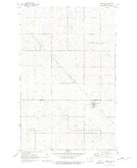
1970 Map of Hampden
USGS Topo · Published 1978About this map
Hampden and the surrounding prairie of Ramsey and Cavalier Counties are captured here following a 1970 field check. The landscape is defined by the Burlington Northern railroad corridor, which links the small grain-handling settlements of Alsen, Weaver, and Hampden. This era shows the organized grid of townships such as Banner, Storlie, Royalo, and Northfield, each reflecting the early 20th-century land division that shaped North Dakota's agricultural development. Local history is anchored by landmarks like the Storlie Cem and a small Park within the Hampden townsite. The topography is typical of the glaciated plains, peppered with numerous small depressions and potholes, while the presence of a Gravel Pit suggests the local extraction of materials for the area's road network.
Find a feature on this map
14 named features on this map. Tap any name to fly to it.
Don’t see what you’re looking for? This feature index may not catch every label — zoom into the map to look around manually.
Map Details
Editions of this 1970 Hampden Map
2 editions found
Other maps of this area

1953 · Devils Lake
USGS Topo · 1:250,000

1956 · Devils Lake
USGS Topo · 1:250,000

1962 · Starkweather NE
USGS Topo · 1:24,000

1970 · Alsen
USGS Topo · 1:24,000

1970 · Loma
USGS Topo · 1:24,000

1970 · Alsen SE
USGS Topo · 1:24,000

1970 · Hampden
USGS Topo · 1:24,000

1970 · Munich
USGS Topo · 1:24,000

1971 · Munich SE
USGS Topo · 1:24,000

1972 · Derrick NW
USGS Topo · 1:24,000