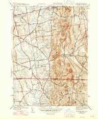
1944 Map of Hampden
USGS Topo · Published 1947About this map
Hampden serves as the focal point of this mid-1940s landscape, positioned where the Scantic River cuts through the steep slopes of Minnechoag Mountain. The area reflects a late-war transition, showing the intersection of agricultural roots and the emerging educational and recreational identity of the Pioneer Valley. Along the northern edge, Wilbraham Academy and the Wilbraham Country Club mark the landscape near Sixteen Acres, while the State Game Farm sits tucked between the North Branch and South Branch Mill River.
Find a feature on this map
68 named features on this map. Tap any name to fly to it.
Don’t see what you’re looking for? This feature index may not catch every label — zoom into the map to look around manually.
Map Details
Editions of this 1944 Hampden Map
4 editions found
Other maps of this area

1886 · Springfield
USGS Topo · 1:62,500

1887 · Palmer
USGS Topo · 1:62,500

1889 · Springfield
USGS Topo · 1:62,500

1889 · Palmer
USGS Topo · 1:62,500

1892 · Hartford
USGS Topo · 1:62,500

1892 · Tolland
USGS Topo · 1:62,500

1893 · Springfield
USGS Topo · 1:62,500

1893 · Palmer
USGS Topo · 1:62,500

1895 · Springfield
USGS Topo · 1:62,500

1896 · Holyoke
USGS Topo · 1:125,000