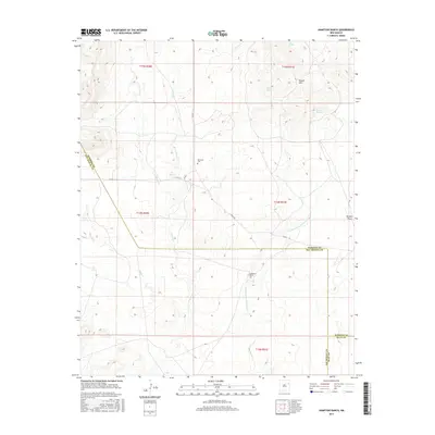
2017 Map of Hampton Ranch
USGS Topo · Published 2017About this map
Bryantine Cem stands as a lonely marker of early settlement within this high-plains landscape where San Miguel, Harding, and Quay counties converge. The terrain is defined by a dendritic network of drainages, including Carros Cr, Conejo Cr, and Wynn Cr, which carve through the arid plateaus. While the Hampton Ranch serves as a primary contemporary landmark, the map reveals the critical importance of water in this environment through numerous named water sources such as Luis Spring, Ramirez Spring, Garcia Spring, and the simply titled The Spring. A complex system of county roads, including Co RD C and Trigg Rd, provides the essential skeleton for ranching operations. The topography transitions from the elevated Gravel Hills in the northeast to the broad expanse of Romero Draw, reflecting the subtle but significant elevation changes that dictate the region's land use.
Find a feature on this map
24 named features on this map. Tap any name to fly to it.
Don’t see what you’re looking for? This feature index may not catch every label — zoom into the map to look around manually.
Map Details
Editions of this 2017 Hampton Ranch Map
This is the sole edition of this map. No revisions or reprints were ever made.
Other maps of this area

1930 · Tucumcari
USGS Topo · 1:125,000

1954 · Tucumcari
USGS Topo · 1:250,000

1958 · Tucumcari
USGS Topo · 1:250,000

1967 · Trinchera Creek
USGS Topo · 1:24,000

1968 · Bascom Camp
USGS Topo · 1:24,000

1968 · Hampton Ranch
USGS Topo · 1:24,000

1968 · Hudson
USGS Topo · 1:24,000

1968 · Montesito Creek
USGS Topo · 1:24,000
1968 · Medina Mesa
USGS Topo · 1:24,000

1969 · Gallegos
USGS Topo · 1:24,000