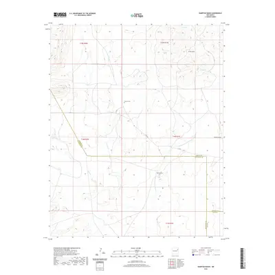
2020 Map of Hampton Ranch
USGS Topo · Published 2020About this map
Hampton Ranch is the focal point of this arid landscape in San Miguel County, situated along the upper reaches of the Northeast Fork Carros Cr. The terrain is defined by a series of high mesas and deep draws typical of northeastern New Mexico's ranching country, including the Romero Draw and the prominent Medina Mesa to the west. While much of the land is remote, the presence of several established water sources such as Luis Spring and Garcia Spring explains the historic viability of livestock operations in this high-plains environment. The map captures the intersection of major county boundaries, where San Miguel, Harding, and Quay counties converge, illustrating the administrative complexity of these sprawling rural territories. Small family burial sites and legacy ranch boundaries, like the Bryantine Cem, reflect the generational continuity of the families who settled this high ground north of the Canadian River valley.
Find a feature on this map
3 named features on this map. Tap any name to fly to it.
Don’t see what you’re looking for? This feature index may not catch every label — zoom into the map to look around manually.
Map Details
Editions of this 2020 Hampton Ranch Map
This is the sole edition of this map. No revisions or reprints were ever made.
Other maps of this area

1930 · Tucumcari
USGS Topo · 1:125,000

1954 · Tucumcari
USGS Topo · 1:250,000

1958 · Tucumcari
USGS Topo · 1:250,000

1967 · Trinchera Creek
USGS Topo · 1:24,000

1968 · Bascom Camp
USGS Topo · 1:24,000

1968 · Hampton Ranch
USGS Topo · 1:24,000

1968 · Hudson
USGS Topo · 1:24,000

1968 · Montesito Creek
USGS Topo · 1:24,000
1968 · Medina Mesa
USGS Topo · 1:24,000

1969 · Gallegos
USGS Topo · 1:24,000