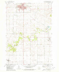
1979 Map of Hampton South
USGS Topo · Published 1980About this map
The county seat of Hampton serves as the focal point for this late-1970s survey, characterized by a grid-like settlement pattern atop the Iowa prairie. The landscape is defined by the agricultural and industrial infrastructure of Franklin County, with the Chicago and North Western railroad corridor providing a backbone for the transport of local commodities. Outside the primary hub, the smaller settlements of Geneva and Bradford anchor their respective townships, while the path of Maynes Creek carves a more organic trail through the rectangular fields. Cultural landmarks such as the Franklin Memorial Hospital and the Jr High Sch are clearly marked within the city, reflecting the community's post-war development. Several rural cemeteries, including Towle Cem and Maysville Cem, are preserved across the quadrangle, offering critical documentation for genealogical research and historical land use studies.
Find a feature on this map
33 named features on this map. Tap any name to fly to it.
Don’t see what you’re looking for? This feature index may not catch every label — zoom into the map to look around manually.
Map Details
Editions of this 1979 Hampton South Map
This is the sole edition of this map. No revisions or reprints were ever made.
Other maps of this area

1954 · Waterloo
USGS Topo · 1:250,000

1955 · Waterloo
USGS Topo · 1:250,000

1972 · Hansell
USGS Topo · 1:24,000

1972 · Latimer
USGS Topo · 1:24,000

1972 · Hampton North
USGS Topo · 1:24,000

1979 · Ackley NE
USGS Topo · 1:24,000

1979 · Coulter
USGS Topo · 1:24,000

1979 · Iowa Falls West
USGS Topo · 1:24,000

1979 · Ackley
USGS Topo · 1:24,000

1979 · Iowa Falls East
USGS Topo · 1:24,000