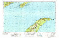
1958 Map of Hancock
USGS Topo · Published 1976About this map
Isle Royale and the Keweenaw Peninsula dominate this mid-century survey of the northernmost reaches of the Upper Peninsula and its surrounding waters. The industrial legacy of the Copper Country is evident in the dense cluster of settlements around Hancock and Houghton, where the Quincy Mine and Franklin Mine overlook the waters of Portage Lake. To the north, the landscape transitions into the remote wilderness of Isle Royale National Park, marked by prominent ridges like Feldtmann Ridge and the Rock of Ages Light warning mariners of the Lake Superior shoals.
Find a feature on this map
144 named features on this map. Tap any name to fly to it.
Don’t see what you’re looking for? This feature index may not catch every label — zoom into the map to look around manually.
Map Details
Editions of this 1958 Hancock Map
2 editions found

Other maps of this area

1895 · Passage Island
USGS Topo · 1:62,500

1915 · Houghton
USGS Topo · 1:62,500

1927 · Point Isabelle
USGS Topo · 1:31,680

1938 · Bruneau Creek
USGS Topo · 1:31,680

1938 · Gay
USGS Topo · 1:31,680

1938 · Delaware
USGS Topo · 1:31,680

1939 · Deer Lake
USGS Topo · 1:31,680

1939 · Delaware
USGS Topo · 1:31,680

1940 · Deer Lake
USGS Topo · 1:31,680
1940 · Manitou Island
USGS Topo · 1:31,680