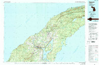
1985 Map of Hancock
USGS Topo · Published 1991About this map
Copper mining heritage and the industrial legacy of the Keweenaw Peninsula define this mid-1980s look at the Copper Country. The twin cities of Hancock and Houghton sit at the center of the sheet, connected by their shared position on Portage Lake, while the educational hub of Mich Tech marks the southern shore. The map illustrates a landscape shaped by mineral extraction, tracing the mineral range from Painesdale and South Range northeast through Calumet and Laurium to the mining settlements of Ahmeek and Mohawk.
Find a feature on this map
150 named features on this map. Tap any name to fly to it.
Don’t see what you’re looking for? This feature index may not catch every label — zoom into the map to look around manually.
Map Details
Editions of this 1985 Hancock Map
3 editions found
Other maps of this area

1915 · Houghton
USGS Topo · 1:62,500

1927 · Point Isabelle
USGS Topo · 1:31,680

1938 · Bruneau Creek
USGS Topo · 1:31,680

1938 · Gay
USGS Topo · 1:31,680

1938 · Delaware
USGS Topo · 1:31,680

1939 · Deer Lake
USGS Topo · 1:31,680

1939 · Delaware
USGS Topo · 1:31,680

1940 · Deer Lake
USGS Topo · 1:31,680

1940 · Central
USGS Topo · 1:31,680

1940 · Lake Medora
USGS Topo · 1:31,680