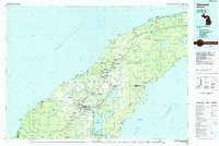
1985 Map of Hancock
USGS Topo · Published 1985About this map
Copper mining heritage dominates the Keweenaw Peninsula in this mid-1980s look at the Copper Country. The twin cities of Houghton and Hancock serve as the focal point, separated by the deep waters of Portage Lake and connected to the academic hub of Mich Tech Univ. The map documents the industrial footprint of the region's mineral wealth, showing significant sites such as the Quincy Mine, Franklin Mine, and Seneca Mine, along with the Quincy Mill on the shoreline. Outside the primary urban centers, the landscape is dotted with smaller mining settlements like Allouez, Ahmeek, and Mohawk. Beyond the mine shafts, the geography transitions into the Copper Country State Forest, where the rugged coast of Lake Superior is marked by the Sand Hills Lighthouse and quiet harbors like Eagle Harbor and Lac La Belle. An Old RR Grade winds through the terrain, tracing the path of former rail lines that once powered the local economy.
Find a feature on this map
151 named features on this map. Tap any name to fly to it.
Don’t see what you’re looking for? This feature index may not catch every label — zoom into the map to look around manually.
Map Details
Editions of this 1985 Hancock Map
3 editions found
Other maps of this area

1915 · Houghton
USGS Topo · 1:62,500

1927 · Point Isabelle
USGS Topo · 1:31,680

1938 · Bruneau Creek
USGS Topo · 1:31,680

1938 · Gay
USGS Topo · 1:31,680

1938 · Delaware
USGS Topo · 1:31,680

1939 · Deer Lake
USGS Topo · 1:31,680

1939 · Delaware
USGS Topo · 1:31,680

1940 · Deer Lake
USGS Topo · 1:31,680

1940 · Central
USGS Topo · 1:31,680

1940 · Lake Medora
USGS Topo · 1:31,680