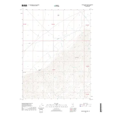
2018 Map of Hand-me-down Creek
USGS Topo · Published 2018About this map
Crescent Valley and the Cortez Mountains define this high-desert landscape in Eureka County, where water is the primary architect of the terrain. The transition from the flat basin of the valley floor to the sharp rises of Cottonwood Canyon and Brock Canyon is marked by a network of drainage channels and vital water sources. Numerous named springs, including Florio Spring Number Ten and Florio Spring Number Six, suggest a history of range management and livestock grazing in an arid environment. The map details the complex hydrology of the area, tracing the paths of Hand-me-down Cr and Duff Cr as they move from the mountain slopes toward the valley. Only a few arterial routes like Danna Rd traverse this sparsely settled corner of Nevada, emphasizing the isolation and topographic dominance of the mountain range.
Find a feature on this map
26 named features on this map. Tap any name to fly to it.
Don’t see what you’re looking for? This feature index may not catch every label — zoom into the map to look around manually.
Map Details
Editions of this 2018 Hand-me-down Creek Map
This is the sole edition of this map. No revisions or reprints were ever made.
Other maps of this area

1938 · Cortez
USGS Topo · 1:48,000

1944 · Cortez
USGS Topo · 1:62,500

1949 · Crescent Valley
USGS Topo · 1:62,500

1950 · Crescent Valley
USGS Topo · 1:62,500

1955 · Winnemucca
USGS Topo · 1:250,000

1957 · Frenchie Creek
USGS Topo · 1:62,500

1957 · Horse Creek Valley
USGS Topo · 1:62,500

1958 · Winnemucca
USGS Topo · 1:250,000

1962 · Winnemucca
USGS Topo · 1:250,000
1985 · Thatcher Spring
USGS Topo · 1:24,000