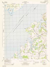
1944 Map of Hanesville
USGS Topo · Published 1944About this map
The eastern shore of Chesapeake Bay in Kent County is defined here by a network of tidal inlets and established agricultural settlements. Centered on the intricate coastline between Still Pond and Fairlee Creek, this mid-century survey illustrates the rural character of Worton and Fairlee districts. Small community hubs like Hanesville and Newtown are documented alongside local centers of faith and education, including St James Church and the Worton Point School.
Find a feature on this map
40 named features on this map. Tap any name to fly to it.
Don’t see what you’re looking for? This feature index may not catch every label — zoom into the map to look around manually.
Map Details
Editions of this 1944 Hanesville Map
This is the sole edition of this map. No revisions or reprints were ever made.
Other maps of this area

1893 · North Point
USGS Topo · 1:62,500

1893 · Gunpowder
USGS Topo · 1:62,500

1898 · Tolchester
USGS Topo · 1:125,000

1900 · Betterton
USGS Topo · 1:62,500

1901 · Chestertown
USGS Topo · 1:62,500

1901 · Gunpowder
USGS Topo · 1:62,500

1903 · Tolchester
USGS Topo · 1:125,000

1904 · North Point
USGS Topo · 1:62,500

1908 · Tolchester
USGS Topo · 1:125,000

1920 · Chestertown
USGS Topo · 1:62,500
Featured Places
- Buck Neck Landing, MD
- Worton Heights, MD
- Great Oak Manor, MD
- Great Oak Landing, MD
- Chesapeake Landing, MD