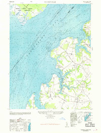
1969 Map of Hanesville
USGS Topo · Published 1969About this map
The eastern shore of the Chesapeake Bay reveals a landscape defined by deeply incised tidal creeks and the long-established agricultural necks of Kent County. During the late 1940s, this area maintained a traditional coastal character, where water access points like Green Point Wharf and Buck Neck Landing remained central to local movement. Inland, the settlements of Hanesville, Melitota, and Newtown are anchored by prominent community landmarks including St Georges Church and St James Church. The map captures a period of transition where traditional land use, exemplified by the Worton Point Orchard and Churn Creek Farm, coexisted with modern additions such as a private Airstrip on Fairlee Neck. Across the bay, the southern extent of the Aberdeen Proving Ground Military Reservation occupies Monks Island and Abbey Point, marking the military's significant footprint on the Chesapeake shoreline.
Find a feature on this map
44 named features on this map. Tap any name to fly to it.
Don’t see what you’re looking for? This feature index may not catch every label — zoom into the map to look around manually.
Map Details
Editions of this 1969 Hanesville Map
This is the sole edition of this map. No revisions or reprints were ever made.
Other maps of this area

1893 · North Point
USGS Topo · 1:62,500

1893 · Gunpowder
USGS Topo · 1:62,500

1898 · Tolchester
USGS Topo · 1:125,000

1900 · Betterton
USGS Topo · 1:62,500

1901 · Chestertown
USGS Topo · 1:62,500

1901 · Gunpowder
USGS Topo · 1:62,500

1903 · Tolchester
USGS Topo · 1:125,000

1904 · North Point
USGS Topo · 1:62,500

1908 · Tolchester
USGS Topo · 1:125,000

1920 · Chestertown
USGS Topo · 1:62,500
Featured Places
- Buck Neck Landing, MD
- Worton Heights, MD
- Great Oak Manor, MD
- Great Oak Landing, MD
- Chesapeake Landing, MD