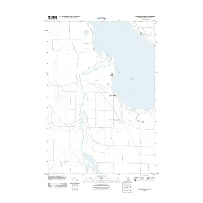
2011 Map of Hangore Heights
USGS Topo · Published 2011About this map
The Black River meanders through this portion of Cheboygan County, defining a landscape of low-lying wetlands and recreational developments south of Black Lake. The settlement of Hangore Heights sits near the lakeshore, supported by local institutions like School 1 and School 2, while Waveland marks a small interior crossroads. This 2011 survey shows a mix of conservation and leisure, with the Black Lake State Forest Campground at the northern edge and the Black Lake Golf Course to the east. For local historians, the Waverly Cemetery provides a key point of genealogical reference. The road network, including the Hutchinson Hwy and Fireline Rd, reflects the area's ongoing management of timberlands and rural residential growth around bodies of water like Mud Lake.
Find a feature on this map
50 named features on this map. Tap any name to fly to it.
Don’t see what you’re looking for? This feature index may not catch every label — zoom into the map to look around manually.
Map Details
Editions of this 2011 Hangore Heights Map
This is the sole edition of this map. No revisions or reprints were ever made.
Other maps of this area

1955 · Cheboygan
USGS Topo · 1:250,000

1957 · Tower
USGS Topo · 1:62,500

1957 · Cheboygan
USGS Topo · 1:62,500

1957 · Onaway
USGS Topo · 1:62,500

1958 · Cheboygan
USGS Topo · 1:250,000

1958 · Grace
USGS Topo · 1:62,500

1982 · Petoskey
USGS Topo · 1:100,000

1982 · Grace
USGS Topo · 1:24,000

1982 · Aloha
USGS Topo · 1:25,000
1982 · Manning
USGS Topo · 1:25,000