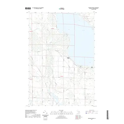
2019 Map of Hangore Heights
USGS Topo · Published 2019About this map
Black River flows north through a landscape of wetlands and varied terrain toward the southern reaches of Black Lake. This corner of Cheboygan County is characterized by a network of local trails and backroads, including the N Eastern State Trail which cuts across the western half of the map. The small settlement of Hangore Heights sits near the river's mouth, while the local geography is punctuated by names like Loren Hill and various water bodies including Kleber Pond and Mud Lake. For those researching family history in Waverly Township, the presence of Waverly Cem and the specific marker for Reuther's Graves offer precise locations for genealogical study. The map shows a region where the water systems of Stewart Cr and Milligan Cr define the drainage patterns of the eastern shoreline.
Find a feature on this map
57 named features on this map. Tap any name to fly to it.
Don’t see what you’re looking for? This feature index may not catch every label — zoom into the map to look around manually.
Map Details
Editions of this 2019 Hangore Heights Map
This is the sole edition of this map. No revisions or reprints were ever made.
Other maps of this area

1955 · Cheboygan
USGS Topo · 1:250,000

1957 · Tower
USGS Topo · 1:62,500

1957 · Cheboygan
USGS Topo · 1:62,500

1957 · Onaway
USGS Topo · 1:62,500

1958 · Cheboygan
USGS Topo · 1:250,000

1958 · Grace
USGS Topo · 1:62,500

1982 · Petoskey
USGS Topo · 1:100,000

1982 · Grace
USGS Topo · 1:24,000

1982 · Aloha
USGS Topo · 1:25,000
1982 · Manning
USGS Topo · 1:25,000