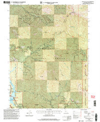
1998 Map of Hanland Peak
USGS Topo · Published 2003About this map
Shasta Lake and its Sacramento River Arm dominate the southwestern corner of this landscape, where the reservoir's fingers reach into the deep canyons of the Shasta-Trinity National Forests. This late-1990s revision shows the recreational development of the shoreline at Antlers Resort and the Antlers Campground, serving as a record of the region's mid-century shift toward a tourism-based economy.
Find a feature on this map
38 named features on this map. Tap any name to fly to it.
Don’t see what you’re looking for? This feature index may not catch every label — zoom into the map to look around manually.
Map Details
Editions of this 1998 Hanland Peak Map
This is the sole edition of this map. No revisions or reprints were ever made.
Other maps of this area

1886 · Shasta
USGS Topo · 1:250,000

1890 · Red Bluff
USGS Topo · 1:250,000

1894 · Red Bluff
USGS Topo · 1:250,000

1894 · Shasta
USGS Topo · 1:250,000

1901 · Redding
USGS Topo · 1:125,000

1935 · Dunsmuir
USGS Topo · 1:125,000

1946 · Lamoine
USGS Topo · 1:62,500

1948 · Weed
USGS Topo · 1:250,000

1949 · Bollibokka Mtn
USGS Topo · 1:62,500

1950 · Weed
USGS Topo · 1:250,000