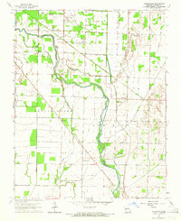
1963 Map of Hanleyville
USGS Topo · Published 1965About this map
Black River meanders through this portion of Butler County, defining a landscape of wetlands and fertile bottoms east of the Poplar Bluff escarpment. The mid-century settlement pattern is anchored by Hanleyville and a dense network of country churches including Giles Chapel, Landreth Chapel, and the Bethlehem Temple. This area shows the heavy reliance on drainage infrastructure common to the region, featuring the Ackerman Ditch and a series of sluggish water bodies like Catherine Slough and Lake Slough. Transport history is visible in the Old Railroad Grade and the Hargrove Bridge crossing. For the genealogist, the map preserves the exact locations of several small community anchors, from the Providence Sch in the north to the Big Island Sch further south, alongside three distinct burial grounds: Morocco Cem, Ashcraft Cem, and Hills Cem.
Find a feature on this map
31 named features on this map. Tap any name to fly to it.
Don’t see what you’re looking for? This feature index may not catch every label — zoom into the map to look around manually.
Map Details
Editions of this 1963 Hanleyville Map
This is the sole edition of this map. No revisions or reprints were ever made.
Other maps of this area

1934 · Puxico
USGS Topo · 1:62,500

1935 · Poplar Bluff
USGS Topo · 1:62,500

1935 · Harviell
USGS Topo · 1:62,500

1939 · Puxico
USGS Topo · 1:62,500

1939 · Poplar Bluff
USGS Topo · 1:62,500

1940 · Valley Ridge
USGS Topo · 1:62,500

1949 · Poplar Bluff
USGS Topo · 1:62,500

1956 · Valley Ridge
USGS Topo · 1:62,500

1957 · Poplar Bluff
USGS Topo · 1:250,000

1959 · Poplar Bluff
USGS Topo · 1:250,000