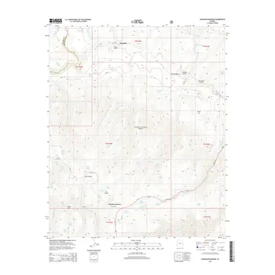
2014 Map of Hannagan Meadow
USGS Topo · Published 2014About this map
Hannagan Meadow and Sprucedale sit within the high-elevation terrain of the Apache National Forest, near the border of Apache and Greenlee counties. This 2014 survey documents a landscape defined by an intricate network of water resources, including numerous tanks and springs such as Taylor Tank and Spring and Middle Turkey Spring. The topography is marked by several significant drainages like Horton Creek and Beaver Creek, which flow through deep incisions like Johns Canyon. Local naming conventions reflect a history of ranching and water management, evidenced by features such as Deep Cienega, Triangle Seeps, and the East Becker Tank. The presence of US Highway 191 provides the primary transit corridor through this wooded area, connecting the small settlements and providing access to remote points like Lost Lake and the Black River.
Find a feature on this map
72 named features on this map. Tap any name to fly to it.
Don’t see what you’re looking for? This feature index may not catch every label — zoom into the map to look around manually.
Map Details
Editions of this 2014 Hannagan Meadow Map
This is the sole edition of this map. No revisions or reprints were ever made.
Other maps of this area

1922 · Nutrioso
USGS Topo · 1:125,000

1954 · Clifton
USGS Topo · 1:250,000

1957 · Clifton
USGS Topo · 1:250,000

1958 · Clifton
USGS Topo · 1:250,000

1958 · Alpine
USGS Topo · 1:62,500

1958 · Hannagan Meadow
USGS Topo · 1:62,500

1958 · Big Lake
USGS Topo · 1:62,500

1961 · Blue
USGS Topo · 1:62,500

1962 · Clifton
USGS Topo · 1:250,000
1981 · Nutrioso
USGS Topo · 1:100,000