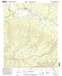
1997 Map of Hannagan Meadow
USGS Topo · Published 2000About this map
Hannagan Meadow and the surrounding high country of the Apache National Forest define this landscape along the Coronado Trail. The map reveals a complex network of high-elevation water management, where numerous tanks like Hoot Owl Tank and Willow Pit Tank serve the livestock needs of the region's ranching heritage. Near the northern boundary, Sprucedale sits near the headwaters of Beaver Creek, while the southwestern corner transitions into the more secluded Blue Range Primitive Area.
Find a feature on this map
83 named features on this map. Tap any name to fly to it.
Don’t see what you’re looking for? This feature index may not catch every label — zoom into the map to look around manually.
Map Details
Editions of this 1997 Hannagan Meadow Map
This is the sole edition of this map. No revisions or reprints were ever made.
Other maps of this area

1922 · Nutrioso
USGS Topo · 1:125,000

1954 · Clifton
USGS Topo · 1:250,000

1957 · Clifton
USGS Topo · 1:250,000

1958 · Clifton
USGS Topo · 1:250,000

1958 · Alpine
USGS Topo · 1:62,500

1958 · Hannagan Meadow
USGS Topo · 1:62,500

1958 · Big Lake
USGS Topo · 1:62,500

1961 · Blue
USGS Topo · 1:62,500

1962 · Clifton
USGS Topo · 1:250,000
1981 · Nutrioso
USGS Topo · 1:100,000