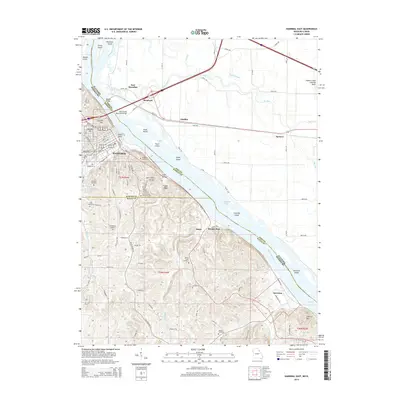
2014 Map of Hannibal East
USGS Topo · Published 2014About this map
Hannibal sits as the central focal point along the western bank of the Mississippi River, where the Mark Twain Memorial Bridge and Wabash Bridge connect Missouri to the riverine lowlands of East Hannibal, Illinois. The landscape transitions from the dense urban grid of Hannibal to the dramatic bluffs of Cardiff Hill and Holliday Hill. To the south, the industrial and residential footprint of Ilasco and Saverton follows the river's curve, flanked by notable topographic features like Fall Creek Gorge and Lookout Mtn. This river-fronting corridor is heavily marked by local history, visible in the numerous burial grounds such as Riverside Cemetery, Mount Olivet Cemetery, and Brinkmeier Cemetery that dot the hillsides. The eastern portion of the survey is dominated by the intricate hydrology of The Sny and Eagle Slough, reflecting the complex floodplain management required in this historic river crossing.
Find a feature on this map
64 named features on this map. Tap any name to fly to it.
Don’t see what you’re looking for? This feature index may not catch every label — zoom into the map to look around manually.
Map Details
Editions of this 2014 Hannibal East Map
This is the sole edition of this map. No revisions or reprints were ever made.
Other maps of this area

1925 · Quincy
USGS Topo · 1:62,500

1925 · Liberty
USGS Topo · 1:62,500

1927 · Liberty
USGS Topo · 1:62,500

1931 · Barry
USGS Topo · 1:62,500

1932 · Hannibal
USGS Topo · 1:62,500

1936 · Hannibal
USGS Topo · 1:48,000

1936 · Barry
USGS Topo · 1:48,000

1944 · Barry
USGS Topo · 1:62,500

1944 · Quincy
USGS Topo · 1:62,500

1945 · Hannibal
USGS Topo · 1:62,500