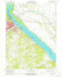
1971 Map of Hannibal East
USGS Topo · Published 1973About this map
Hannibal sits as the primary urban center on this Missouri riverfront, where the Burlington Northern and Norfolk and Western railroads converge to cross the Mississippi River. This era shows a landscape deeply tied to its natural limestone features and literary legacy, notably marked by Mark Twain Cave, Cameron Cave, and the landmark Cardiff Hill. Beyond the city limits, the terrain transitions into the wooded hills of Saverton township, punctuated by numerous industrial operations including an extensive network of quarries and mines.
Find a feature on this map
72 named features on this map. Tap any name to fly to it.
Don’t see what you’re looking for? This feature index may not catch every label — zoom into the map to look around manually.
Map Details
Editions of this 1971 Hannibal East Map
This is the sole edition of this map. No revisions or reprints were ever made.
Other maps of this area

1925 · Quincy
USGS Topo · 1:62,500

1925 · Liberty
USGS Topo · 1:62,500

1927 · Liberty
USGS Topo · 1:62,500

1931 · Barry
USGS Topo · 1:62,500

1932 · Hannibal
USGS Topo · 1:62,500

1936 · Hannibal
USGS Topo · 1:48,000

1936 · Barry
USGS Topo · 1:48,000

1944 · Barry
USGS Topo · 1:62,500

1944 · Quincy
USGS Topo · 1:62,500

1945 · Hannibal
USGS Topo · 1:62,500