
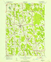
1943 Map of Hannibal
USGS Topo · Published 1943About this map
The Hannibal village and its surrounding rural hamlets are mapped here during the early 1940s by the War Department and Corps of Engineers. This agricultural landscape is defined by a high density of local school districts, including School No 7 and School No 12, which serve the small communities and farmsteads scattered across the Cayuga and Oswego county line. The Lehigh Valley railroad cuts a diagonal path through the terrain, connecting the village of Martville with the larger hub at Hannibal.
Find a feature on this map
52 named features on this map. Tap any name to fly to it.
Don’t see what you’re looking for? This feature index may not catch every label — zoom into the map to look around manually.
Map Details
Editions of this 1943 Hannibal Map
2 editions found
Other maps of this area

1900 · Baldwinsville
USGS Topo · 1:62,500

1900 · Oswego
USGS Topo · 1:62,500

1900 · Fulton
USGS Topo · 1:62,500

1902 · Weedsport
USGS Topo · 1:62,500

1943 · Oswego East
USGS Topo · 1:31,680

1943 · Lysander
USGS Topo · 1:31,680

1943 · Oswego West
USGS Topo · 1:31,680

1943 · Cato
USGS Topo · 1:31,680

1943 · Fair Haven
USGS Topo · 1:31,680
1943 · Red Creek
USGS Topo · 1:31,680