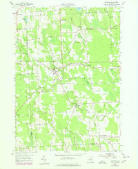
1978 Map of Hannibal
USGS Topo · Published 1978About this map
Hannibal serves as the central hub of this late-1970s survey, where the intersection of several regional roads anchors a landscape of small agricultural settlements and rural industry. The map illustrates a developed network of hamlets including Hannibal Center, North Hannibal, and South Hannibal, as well as named crossroads like Kinney Corners and Pember Corners. The presence of the Metcalf Siding and a Quarry near the center of the township reflects the area's local economic activity during this era.
Find a feature on this map
66 named features on this map. Tap any name to fly to it.
Don’t see what you’re looking for? This feature index may not catch every label — zoom into the map to look around manually.
Map Details
Editions of this 1978 Hannibal Map
This is the sole edition of this map. No revisions or reprints were ever made.
Other maps of this area

1900 · Baldwinsville
USGS Topo · 1:62,500

1900 · Oswego
USGS Topo · 1:62,500

1900 · Fulton
USGS Topo · 1:62,500

1902 · Weedsport
USGS Topo · 1:62,500

1943 · Oswego East
USGS Topo · 1:31,680

1943 · Lysander
USGS Topo · 1:31,680

1943 · Oswego West
USGS Topo · 1:31,680

1943 · Cato
USGS Topo · 1:31,680

1943 · Hannibal
USGS Topo · 1:31,680

1943 · Fair Haven
USGS Topo · 1:31,680