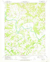
1971 Map of Hannibal SE
USGS Topo · Published 1973About this map
The winding Salt River dominates the landscape of southern Ralls County in this 1971 survey, carving a deep valley through the limestone bluffs. This era captures the rural character of the region before significant modern development, showing a countryside densely populated with family burial grounds such as Salt River Cem, Sinklear Cem, and Kiethley Cem. The presence of Fisher Cave and Scantland Cave points to the underlying karst topography typical of this part of Missouri.
Find a feature on this map
39 named features on this map. Tap any name to fly to it.
Don’t see what you’re looking for? This feature index may not catch every label — zoom into the map to look around manually.
Map Details
Editions of this 1971 Hannibal SE Map
2 editions found
Other maps of this area

1890 · Louisiana
USGS Topo · 1:125,000

1931 · Barry
USGS Topo · 1:62,500

1932 · Hannibal
USGS Topo · 1:62,500

1936 · Hannibal
USGS Topo · 1:48,000

1936 · Barry
USGS Topo · 1:48,000

1937 · Bowling Green
USGS Topo · 1:62,500

1940 · Bowling Green
USGS Topo · 1:62,500

1943 · Vandalia
USGS Topo · 1:62,500

1944 · Barry
USGS Topo · 1:62,500

1945 · Hannibal
USGS Topo · 1:62,500