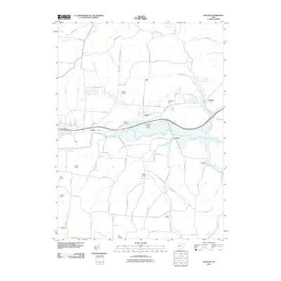
2010 Map of Hanover
USGS Topo · Published 2010About this map
The Licking River carves through this central Ohio landscape, anchoring a network of small settlements and rural homesteads. The village of Hanover sits in the northeast corner, while smaller hubs like Marne, Swans, and Claylick follow the path of the river and the road network. For those tracing local roots, the map is remarkably well-documented with family and community landmarks, including the Bowling Green Cemetery and the Ellis Chapel Cemetery. The terrain is defined by several prominent rises, such as Coshocton Hill and Bucks Knob, which overlook the surrounding drainages of Claylick Creek and Bowling Green Run. A notable natural feature is the Bowling Green Prairie, preserved amidst the agricultural and residential development that spans the townships. This document provides a clear view of the rural infrastructure at the start of the 21st century, from the winding paths of Flint Ridge Rd SE to the established churchyards like Pleasant Chapel Cemetery.
Find a feature on this map
84 named features on this map. Tap any name to fly to it.
Don’t see what you’re looking for? This feature index may not catch every label — zoom into the map to look around manually.
Map Details
Editions of this 2010 Hanover Map
This is the sole edition of this map. No revisions or reprints were ever made.
Other maps of this area

1909 · Newark
USGS Topo · 1:62,500

1909 · Thornville
USGS Topo · 1:62,500

1910 · Frazeysburg
USGS Topo · 1:62,500

1910 · Zanesville
USGS Topo · 1:62,500

1947 · Columbus
USGS Topo · 1:250,000

1950 · Marion
USGS Topo · 1:250,000

1961 · Columbus
USGS Topo · 1:250,000

1961 · Hanover
USGS Topo · 1:24,000

1961 · Newark
USGS Topo · 1:24,000
1961 · Thornville
USGS Topo · 1:24,000