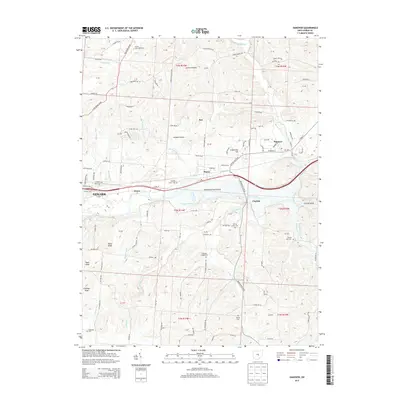
2013 Map of Hanover
USGS Topo · Published 2013About this map
The Licking River carves a central path through this part of Licking County, defining a landscape where valley settlements like Marne and Claylick meet the rising terrain of Coshocton Hill and London Hollow. This 2013 survey illustrates the modern road network surrounding Newark, while preserving the locations of numerous historic burial grounds that serve as vital links for local genealogists, including Bowling Green Cem and Spring Grove Cem. The map reveals a diverse topography, from the level expanse of Bowling Green Prairie to the dramatic incision of the Licking Gorge in the east. North of the river, the Brandt Trout Hatchery utilizes the spring-fed waters of the region, while the southern hills are dotted with peaks like Bucks Knob and Bald Knob. The presence of Swans and Hanover further identifies the long-standing transport and community hubs that have persisted along these river corridors.
Find a feature on this map
124 named features on this map. Tap any name to fly to it.
Don’t see what you’re looking for? This feature index may not catch every label — zoom into the map to look around manually.
Map Details
Editions of this 2013 Hanover Map
This is the sole edition of this map. No revisions or reprints were ever made.
Other maps of this area

1909 · Newark
USGS Topo · 1:62,500

1909 · Thornville
USGS Topo · 1:62,500

1910 · Frazeysburg
USGS Topo · 1:62,500

1910 · Zanesville
USGS Topo · 1:62,500

1947 · Columbus
USGS Topo · 1:250,000

1950 · Marion
USGS Topo · 1:250,000

1961 · Columbus
USGS Topo · 1:250,000

1961 · Hanover
USGS Topo · 1:24,000

1961 · Newark
USGS Topo · 1:24,000
1961 · Thornville
USGS Topo · 1:24,000