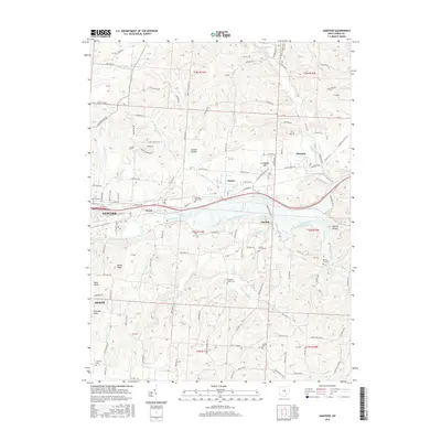
2016 Map of Hanover
USGS Topo · Published 2016About this map
The Licking River winds through the heart of Licking County, defining a valley where small settlements like Hanover and Claylick took root alongside historic transportation corridors. This 2016 survey shows the eastern edges of Newark and Heath as they meet the more rural landscape of London Hollow and Coshocton Hill. The geography is notably punctuated by several local knobs, including Bucks Knob, Bald Knob, and Coffman Knob, which rise above the surrounding creek beds of Claylick Creek and Bowling Green Run. Genealogists will find a high concentration of established burial grounds, from the Bowling Green Cemetery near Marne to the Pleasant Chapel Cemetery and Oakhill Cemetery further south, mapping the long-standing community footprint of the region.
Find a feature on this map
138 named features on this map. Tap any name to fly to it.
Don’t see what you’re looking for? This feature index may not catch every label — zoom into the map to look around manually.
Map Details
Editions of this 2016 Hanover Map
This is the sole edition of this map. No revisions or reprints were ever made.
Other maps of this area

1909 · Newark
USGS Topo · 1:62,500

1909 · Thornville
USGS Topo · 1:62,500

1910 · Frazeysburg
USGS Topo · 1:62,500

1910 · Zanesville
USGS Topo · 1:62,500

1947 · Columbus
USGS Topo · 1:250,000

1950 · Marion
USGS Topo · 1:250,000

1961 · Columbus
USGS Topo · 1:250,000

1961 · Hanover
USGS Topo · 1:24,000

1961 · Newark
USGS Topo · 1:24,000
1961 · Thornville
USGS Topo · 1:24,000