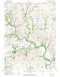
1966 Map of Hanover West
USGS Topo · Published 1967About this map
The Little Blue River and Mill Creek converge in this mid-1960s landscape, illustrating the agricultural and rail-oriented layout of northern Washington County. This survey captures a specific historical marker of the 19th-century frontier: the Old Indian Treaty Boundary, which cuts across the northern townships of Franklin and Independence. The rail infrastructure is well-defined, showing the paths of the Union Pacific and the C B & Q, which supported the small riverside communities of Hollenberg, Spence, and Hanover.
Find a feature on this map
27 named features on this map. Tap any name to fly to it.
Don’t see what you’re looking for? This feature index may not catch every label — zoom into the map to look around manually.
Map Details
Editions of this 1966 Hanover West Map
2 editions found
Other maps of this area

1889 · Marysville
USGS Topo · 1:125,000

1893 · Washington
USGS Topo · 1:125,000

1894 · Marysville
USGS Topo · 1:125,000

1955 · Manhattan
USGS Topo · 1:250,000

1955 · Lincoln
USGS Topo · 1:250,000

1956 · Manhattan
USGS Topo · 1:250,000

1957 · Manhattan
USGS Topo · 1:250,000

1957 · Lincoln
USGS Topo · 1:250,000

1958 · Lincoln
USGS Topo · 1:250,000

1966 · Washington
USGS Topo · 1:24,000