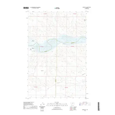
2020 Map of Hanson Flat
USGS Topo · Published 2020About this map
Fort Peck Lake dominates the central landscape of this Montana quadrangle, where the Missouri River is broad and complex as it meets the reservoir waters. Along the northern and southern banks, the river's historical path is traced by low-lying areas like Miller Bottoms and Hutton Bottoms. These riparian zones are flanked by a series of erosion-carved drainages including Carroll Coulee and Fisher Coulee, which cut through the high plains. Historic travel through this territory is marked by several established paths, most notably the Old Musselshell Trl and the Horse Camp Trl in the southern reaches, and the Wilder Trl near the river. The map also delineates the convergence of Fergus, Phillips, and Petroleum counties, highlighting how these modern administrative boundaries navigate the terrain of Hanson Flat.
Find a feature on this map
21 named features on this map. Tap any name to fly to it.
Don’t see what you’re looking for? This feature index may not catch every label — zoom into the map to look around manually.
Map Details
Editions of this 2020 Hanson Flat Map
This is the sole edition of this map. No revisions or reprints were ever made.
Other maps of this area

1954 · Lewistown
USGS Topo · 1:250,000

1959 · Lewistown
USGS Topo · 1:250,000

1965 · Dry Coulee
USGS Topo · 1:24,000

1965 · Lake Reservoir
USGS Topo · 1:24,000

1965 · Weingart Place NW
USGS Topo · 1:24,000

1971 · Blizzard Reservoir
USGS Topo · 1:24,000

1971 · Kepple Bottoms
USGS Topo · 1:24,000
1971 · Sagebrush Reservoir
USGS Topo · 1:24,000

1971 · Hanson Flat
USGS Topo · 1:24,000

1984 · Zortman
USGS Topo · 1:100,000