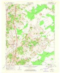
1969 Map of Hanson
USGS Topo · Published 1971About this map
The Louisville and Nashville railroad corridor defines the western edge of this Kentucky landscape, running parallel to the Pennyrile Parkway through the settlements of Slaughters and Hanson. This late-1960s survey illustrates a region where rural community life and industrial extraction exist side-by-side. Pockets of extractive activity are visible throughout the central hills, marked by numerous Oil Wells and Gas Wells, particularly in the areas surrounding Vandetta and the Otter Creek drainage.
Find a feature on this map
49 named features on this map. Tap any name to fly to it.
Don’t see what you’re looking for? This feature index may not catch every label — zoom into the map to look around manually.
Map Details
Editions of this 1969 Hanson Map
This is the sole edition of this map. No revisions or reprints were ever made.
Other maps of this area

1906 · Sebree
USGS Topo · 1:62,500

1907 · Earlington
USGS Topo · 1:48,000

1908 · Calhoun
USGS Topo · 1:62,500

1909 · Earlington
USGS Topo · 1:62,500

1909 · Madisonville
USGS Topo · 1:62,500

1949 · Sebree
USGS Topo · 1:24,000

1951 · Sebree
USGS Topo · 1:24,000

1952 · Sacramento
USGS Topo · 1:24,000

1952 · Calhoun
USGS Topo · 1:24,000

1952 · Beech Grove
USGS Topo · 1:24,000