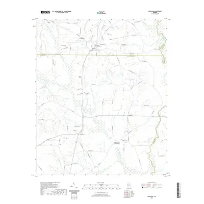
2020 Map of Haralson
USGS Topo · Published 2020About this map
The town of Haralson sits at the intersection of Coweta and Meriwether counties, anchoring a landscape defined by small communities and rural family estates. To the south, the settlements of Alvaton and Carmel are connected by local routes like Sullivan Mill Rd, while the area around Alps reflects the quiet, agricultural character of the Georgia Piedmont. The presence of several family and community burial grounds, including Haralson Cem, Owens Cem, and Connally Cem, provides significant geographic markers for local genealogy.
Find a feature on this map
108 named features on this map. Tap any name to fly to it.
Don’t see what you’re looking for? This feature index may not catch every label — zoom into the map to look around manually.
Map Details
Editions of this 2020 Haralson Map
This is the sole edition of this map. No revisions or reprints were ever made.
Other maps of this area

1953 · Atlanta
USGS Topo · 1:250,000

1957 · Atlanta
USGS Topo · 1:250,000

1958 · Atlanta
USGS Topo · 1:250,000

1965 · Senoia
USGS Topo · 1:24,000

1965 · Brooks
USGS Topo · 1:24,000

1965 · Sharpsburg
USGS Topo · 1:24,000
1971 · Luthersville
USGS Topo · 1:24,000
1971 · Greenville
USGS Topo · 1:24,000

1971 · Hollonville
USGS Topo · 1:24,000
1971 · Haralson
USGS Topo · 1:24,000