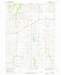
1970 Map of Harbine
USGS Topo · Published 1972About this map
The Chicago Rock Island and Pacific railroad bisects this rural Nebraska landscape, defining the development of small settlements like Harbine and Ellis. Surveyed for the Missouri River Basin development program, the map documents a transition in agriculture and transport along the border of Jefferson and Gage Counties. Family and community history is preserved in sites such as the Harbine Cemetery and Prairie Home Cemetery, while local education and worship are anchored by Zion School and Hope Church. Water resources are central to the terrain, with Cub Creek and Indian Creek carving through the townships of Pleasant, Elm, and Lincoln. Numerous labeled wells and a prominent pipeline underscore the infrastructure supporting these Great Plains communities in the early 1970s.
Find a feature on this map
21 named features on this map. Tap any name to fly to it.
Don’t see what you’re looking for? This feature index may not catch every label — zoom into the map to look around manually.
Map Details
Editions of this 1970 Harbine Map
This is the sole edition of this map. No revisions or reprints were ever made.
Other maps of this area

1955 · Lincoln
USGS Topo · 1:250,000

1957 · Lincoln
USGS Topo · 1:250,000

1957 · Plymouth
USGS Topo · 1:24,000

1957 · Beatrice West
USGS Topo · 1:24,000

1958 · Lincoln
USGS Topo · 1:250,000

1961 · Western SE
USGS Topo · 1:24,000

1970 · Diller NE
USGS Topo · 1:24,000
1970 · Endicott
USGS Topo · 1:24,000

1970 · Diller
USGS Topo · 1:24,000
1970 · Odell
USGS Topo · 1:24,000