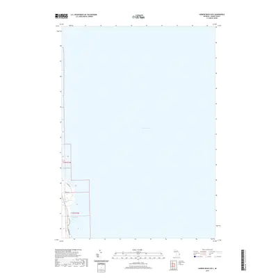
2019 Map of Harbor Beach OE E
USGS Topo · Published 2019About this map
Lake Huron dominates this shoreline survey of Sherman Township in Huron County, Michigan. The landscape is defined by the thin strip of coastal development where the land meets the lake at Sharpe Bay and Purdy Bay. The road network, including Lakeside Dr and Old Lakeshore Rd, follows the natural curve of the coast, reflecting a residential and seasonal pattern of settlement typical of Michigan's Thumb region in the early 21st century. Buckley Cr provides a small break in the terrain as it drains toward the lake, marking one of the few named hydrological features in this immediate coastal area. The map illustrates the precise division of land between t16n r16e and t15n r16e, showcasing the intersection of traditional Public Land Survey System grids with modern lakeside infrastructure like Helena Rd.
Find a feature on this map
10 named features on this map. Tap any name to fly to it.
Don’t see what you’re looking for? This feature index may not catch every label — zoom into the map to look around manually.
Map Details
Editions of this 2019 Harbor Beach OE E Map
This is the sole edition of this map. No revisions or reprints were ever made.
Other maps of this area

1954 · Flint
USGS Topo · 1:250,000

1958 · Flint
USGS Topo · 1:250,000

1963 · Forestville
USGS Topo · 1:24,000

1963 · Ruth
USGS Topo · 1:24,000

1970 · Port Hope
USGS Topo · 1:24,000

1970 · Harbor Beach
USGS Topo · 1:24,000

1984 · Harbor Beach
USGS Topo · 1:100,000
2011 · Forestville
USGS Topo · 1:24,000
2011 · Harbor Beach
USGS Topo · 1:24,000
2011 · Harbor Beach OE E
USGS Topo · 1:24,000