
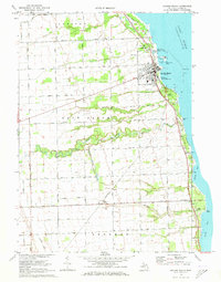
1970 Map of Harbor Beach
USGS Topo · Published 1973About this map
Harbor Beach serves as a major maritime anchor on the Lake Huron shoreline, defined by its extensive harbor works and its role as a regional industrial hub. This early 1970s landscape shows the transition from the bustling waterfront, featuring a Coast Guard Station and prominent Lighthouse, to the agricultural hinterlands of Rubicon and Sand Beach. The Chesapeake and Ohio railroad corridor traces the coastline, supporting the local economy alongside scattered Oil Wells and a Gravel Pit. Inland, the terrain is marked by an intricate network of drainage systems like the Shelke Drain and Jenks Drain, which facilitate farming across the flat lake-plain. The map records important community touchstones for genealogists, including the Wade Sch, Rock Falls Cem, and the small inland settlement of Helena situated along the rail line.
Find a feature on this map
51 named features on this map. Tap any name to fly to it.
Don’t see what you’re looking for? This feature index may not catch every label — zoom into the map to look around manually.
Map Details
Editions of this 1970 Harbor Beach Map
2 editions found
Other maps of this area

1954 · Flint
USGS Topo · 1:250,000

1958 · Flint
USGS Topo · 1:250,000

1963 · Forestville
USGS Topo · 1:24,000

1963 · Ruth
USGS Topo · 1:24,000

1963 · Minden City
USGS Topo · 1:24,000

1970 · Port Hope
USGS Topo · 1:24,000

1970 · Redman
USGS Topo · 1:24,000

1970 · Bad Axe SE
USGS Topo · 1:24,000

1984 · Harbor Beach
USGS Topo · 1:100,000
2011 · Redman
USGS Topo · 1:24,000