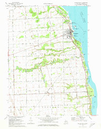
1970 Map of Harbor Beach
USGS Topo · Published 1973About this map
The lakeside harbor of Harbor Beach serves as the focal point of this coastal Huron County survey, where the Chesapeake and Ohio railroad corridor tracks closely with the Lake Huron shoreline. The town's maritime importance is marked by a prominent Lighthouse, a Coast Guard Station, and several recreational points like Bathing Beach Park. Beyond the breakwater, the rural interior is organized by a dense grid of family-named roads such as Klug Road and Hope Road, indicating a landscape deeply settled by agricultural families.
Find a feature on this map
64 named features on this map. Tap any name to fly to it.
Don’t see what you’re looking for? This feature index may not catch every label — zoom into the map to look around manually.
Map Details
Editions of this 1970 Harbor Beach Map
2 editions found
Other maps of this area

1954 · Flint
USGS Topo · 1:250,000

1958 · Flint
USGS Topo · 1:250,000

1963 · Forestville
USGS Topo · 1:24,000

1963 · Ruth
USGS Topo · 1:24,000

1963 · Minden City
USGS Topo · 1:24,000

1970 · Port Hope
USGS Topo · 1:24,000

1970 · Redman
USGS Topo · 1:24,000

1970 · Harbor Beach
USGS Topo · 1:24,000

1970 · Bad Axe SE
USGS Topo · 1:24,000

1984 · Harbor Beach
USGS Topo · 1:100,000