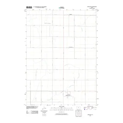
2010 Map of Harcourt
USGS Topo · Published 2010About this map
Harcourt anchors this northern Iowa agricultural landscape, serving as a primary hub for the surrounding rural area. The settlement pattern is defined by a rigorous grid of section lines, including north-south routes like Kansas Ave and Madison Ave, which connect the community to smaller locales such as Lundgren and Palm Grove. This network reflects the organized land division typical of Webster County, where the infrastructure is built to support a high-intensity farming economy. The hydrology of the area shows a transition from natural watercourses to managed systems, evidenced by the winding path of East Buttrick Creek and Crooked Creek alongside engineered solutions like Drainage Ditch Number 29. This 2010 survey records the persistent importance of the town center, centered on the Harcourt Post Office, within a landscape dominated by open fields and drainage management.
Find a feature on this map
24 named features on this map. Tap any name to fly to it.
Don’t see what you’re looking for? This feature index may not catch every label — zoom into the map to look around manually.
Map Details
Editions of this 2010 Harcourt Map
This is the sole edition of this map. No revisions or reprints were ever made.
Other maps of this area

1923 · Lehigh
USGS Topo · 1:62,500

1951 · Ogden
USGS Topo · 1:62,500

1954 · Fort Dodge
USGS Topo · 1:250,000

1957 · Fort Dodge
USGS Topo · 1:250,000

1958 · Fort Dodge
USGS Topo · 1:250,000

1962 · Jefferson
USGS Topo · 1:62,500

1965 · Moorland
USGS Topo · 1:24,000

1965 · Fort Dodge South
USGS Topo · 1:24,000

1965 · Lehigh
USGS Topo · 1:24,000

1965 · Gowrie
USGS Topo · 1:24,000