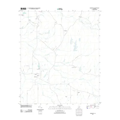
2011 Map of Hardaway
USGS Topo · Published 2011About this map
Cubahatchee Creek and its many winding tributaries, including Coon Hop Creek and Beaverdam Creek, dominate this rural Macon County landscape. The settlement of Hardaway serves as a central hub, anchored by the Hardaway Post Office and its namesake Hardaway Cemetery. The geography is defined by a network of drainage branches and local reservoirs like Moorers Lake, created by the John Frank Moorer Dam. Small family and community burial grounds, such as Cole Cemetery and Grimm Cemetery, are scattered across the terrain, offering significant touchpoints for genealogical research. The road system is a mix of numbered county routes and residential lanes named for birds and local families, connecting outlying areas like Liverpool and Downs to the primary creek valleys.
Find a feature on this map
49 named features on this map. Tap any name to fly to it.
Don’t see what you’re looking for? This feature index may not catch every label — zoom into the map to look around manually.
Map Details
Editions of this 2011 Hardaway Map
This is the sole edition of this map. No revisions or reprints were ever made.
Other maps of this area

1955 · Phenix City
USGS Topo · 1:250,000

1957 · Phenix City
USGS Topo · 1:250,000

1958 · Phenix City
USGS Topo · 1:250,000

1971 · Tuskegee
USGS Topo · 1:24,000

1971 · Shorter
USGS Topo · 1:24,000

1971 · La Place
USGS Topo · 1:24,000

1971 · Hardaway
USGS Topo · 1:24,000

1971 · Thompson
USGS Topo · 1:24,000
1971 · Fitzpatrick
USGS Topo · 1:24,000
1971 · Chesson
USGS Topo · 1:24,000