
1971 Map of Shorter
USGS Topo · Published 1973About this map
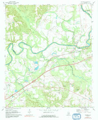
The Tallapoosa River winds through the northern landscape of this 1971 survey, marking the boundary between Elmore and Macon counties. This territory is defined by the convergence of several major tributaries, including Tumkeehatchee Creek, Wallahatchee Creek, and Calebee Creek, which flow through an area heavily shaped by extractive industry. Numerous Gravel Pits are scattered across the terrain, indicating the local economic activity of the era.
Find a feature on this map
26 named features on this map. Tap any name to fly to it.
Don’t see what you’re looking for? This feature index may not catch every label — zoom into the map to look around manually.
Map Details
Editions of this 1971 Shorter Map
2 editions found
Other maps of this area

1901 · Wetumpka
USGS Topo · 1:125,000

1901 · Wetumpka
USGS Topo · 1:62,500

1903 · Wetumpka
USGS Topo · 1:125,000

1906 · Dadeville
USGS Topo · 1:125,000

1953 · Montgomery
USGS Topo · 1:250,000

1955 · Phenix City
USGS Topo · 1:250,000

1956 · Montgomery
USGS Topo · 1:250,000

1957 · Phenix City
USGS Topo · 1:250,000

1957 · Montgomery
USGS Topo · 1:250,000

1958 · Phenix City
USGS Topo · 1:250,000