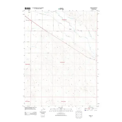
2013 Map of Hardin
USGS Topo · Published 2013About this map
The S Platte River corridor near Hardin defines the landscape of this Weld County region, revealing a complex network of 21st-century water management infrastructure. The map documents the intricate path of the Empire Intake Canal, the Riverside Intake Canal, and the Latham Ditch, which redirect water through the plains to support agricultural life. These engineered waterways parallel the natural course of Box Elder Cr and the river, illustrating the vital reliance on irrigation in eastern Colorado. Small settlements and local landmarks like Kuner and Seventy Ranch are situated along a grid of county roads and the diagonal corridor of US-34, which cuts through the township boundaries of T05N and T04N. The topography is marked by subtle elevation changes and depressions, characteristic of the Platte Valley bottomlands.
Find a feature on this map
25 named features on this map. Tap any name to fly to it.
Don’t see what you’re looking for? This feature index may not catch every label — zoom into the map to look around manually.
Map Details
Editions of this 2013 Hardin Map
This is the sole edition of this map. No revisions or reprints were ever made.
Other maps of this area

1902 · Greeley
USGS Topo · 1:125,000

1950 · Kersey
USGS Topo · 1:24,000

1950 · Tampa
USGS Topo · 1:24,000

1950 · Barnesville
USGS Topo · 1:24,000

1950 · Klug Ranch
USGS Topo · 1:24,000

1950 · Valley View School
USGS Topo · 1:24,000

1950 · Hardin
USGS Topo · 1:24,000
1951 · Klug Ranch
USGS Topo · 1:24,000

1951 · Hardin
USGS Topo · 1:24,000
1951 · Valley View School
USGS Topo · 1:24,000