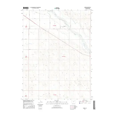
2016 Map of Hardin
USGS Topo · Published 2016About this map
Hardin sits at a critical hydraulic junction in Weld County, where the agricultural lifeblood of the high plains is managed through a complex network of man-made waterways. The South Platte River winds through the northern portion of the landscape, flanked by significant irrigation infrastructure including the Empire Intake Canal and the Riverside Intake Canal. This 2016 survey illustrates how the natural river system has been harnessed for regional development, with Latham Ditch and Box Elder Cr cutting through the terrain to support local water needs. The land is defined by a rigorous grid of county roads, such as Co RD 380 and Co RD 61, which delineate the expansive agricultural parcels characteristic of this part of the Colorado front range.
Find a feature on this map
22 named features on this map. Tap any name to fly to it.
Don’t see what you’re looking for? This feature index may not catch every label — zoom into the map to look around manually.
Map Details
Editions of this 2016 Hardin Map
This is the sole edition of this map. No revisions or reprints were ever made.
Other maps of this area

1902 · Greeley
USGS Topo · 1:125,000

1950 · Kersey
USGS Topo · 1:24,000

1950 · Tampa
USGS Topo · 1:24,000

1950 · Barnesville
USGS Topo · 1:24,000

1950 · Klug Ranch
USGS Topo · 1:24,000

1950 · Valley View School
USGS Topo · 1:24,000

1950 · Hardin
USGS Topo · 1:24,000
1951 · Klug Ranch
USGS Topo · 1:24,000

1951 · Hardin
USGS Topo · 1:24,000
1951 · Valley View School
USGS Topo · 1:24,000