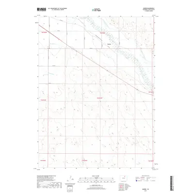
2019 Map of Hardin
USGS Topo · Published 2019About this map
The South Platte River cuts across the northern reaches of this landscape, anchoring a complex system of agricultural water management. The small settlement of Hardin sits near the riverbanks, positioned where the Empire Intake Canal and Riverside Intake Canal diverge to serve the surrounding Weld County plains. This area is defined by the transition between the riparian habitat of the Centennial Valley SWA (east) and the high-desert topography to the south, where Box Elder Cr meanders toward the main river channel. The map illustrates a grid of rural routes including Co RD 50 and Co RD 48, which provide access to the vast open tracts of the Colorado prairie. Historical water rights are evident through features like Latham Ditch, tracing the engineering required to sustain cultivation in this arid environment.
Find a feature on this map
26 named features on this map. Tap any name to fly to it.
Don’t see what you’re looking for? This feature index may not catch every label — zoom into the map to look around manually.
Map Details
Editions of this 2019 Hardin Map
This is the sole edition of this map. No revisions or reprints were ever made.
Other maps of this area

1902 · Greeley
USGS Topo · 1:125,000

1950 · Kersey
USGS Topo · 1:24,000

1950 · Tampa
USGS Topo · 1:24,000

1950 · Barnesville
USGS Topo · 1:24,000

1950 · Klug Ranch
USGS Topo · 1:24,000

1950 · Valley View School
USGS Topo · 1:24,000

1950 · Hardin
USGS Topo · 1:24,000
1951 · Klug Ranch
USGS Topo · 1:24,000

1951 · Hardin
USGS Topo · 1:24,000
1951 · Valley View School
USGS Topo · 1:24,000