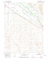
1950 Map of Hardin
USGS Topo · Published 1979About this map
The South Platte River valley dominates this 1950s era survey, revealing an intricate network of irrigation vital to Weld County agriculture. The Union Pacific railroad corridor serves as the primary artery for the small settlements of Hardin and Kuner, with the Kuner School providing a social anchor for the surrounding rural community. The landscape is defined by its water management systems, featuring the Latham Ditch, Empire Intake Canal, and the Riverside Intake Canal, which divert the river's flow to the high plains. A noteworthy piece of local history is the Bijou Canal (Aban'd), marked as abandoned by the time of this mapping. Scattered windmills across the terrain highlight the reliance on groundwater for the Seventy Ranch and other local homesteads during this period of mid-century agricultural development.
Find a feature on this map
18 named features on this map. Tap any name to fly to it.
Don’t see what you’re looking for? This feature index may not catch every label — zoom into the map to look around manually.
Map Details
Editions of this 1950 Hardin Map
2 editions found
Other maps of this area

1902 · Greeley
USGS Topo · 1:125,000

1950 · Kersey
USGS Topo · 1:24,000

1950 · Tampa
USGS Topo · 1:24,000

1950 · Barnesville
USGS Topo · 1:24,000

1950 · Klug Ranch
USGS Topo · 1:24,000

1950 · Valley View School
USGS Topo · 1:24,000

1950 · Hardin
USGS Topo · 1:24,000
1951 · Klug Ranch
USGS Topo · 1:24,000

1951 · Hardin
USGS Topo · 1:24,000
1951 · Valley View School
USGS Topo · 1:24,000