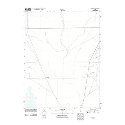
2010 Map of Harding
USGS Topo · Published 2010About this map
Harding occupies a prominent position in this desert landscape of Millard County, situated along a primary transportation route that cuts diagonally through the terrain. The human imprint on the land is defined by an extensive irrigation and water management network, most notably the Central Utah Canal which meanders through the eastern portion of the map. This infrastructure reflects the region's agricultural adaptation to the arid environment of western Utah. To the east, the topography rises toward Sixmile Point, where natural drainage patterns like Sixmile Wash and Clay Spring Wash emerge from the uplands. The road network, including Clay Springs Rd and 6 Mile Rd, follows both the cardinal directions of the township grid and the natural contours of the valley floor, providing a clear view of the rural settlement patterns near Delta during this era.
Find a feature on this map
11 named features on this map. Tap any name to fly to it.
Don’t see what you’re looking for? This feature index may not catch every label — zoom into the map to look around manually.
Map Details
Editions of this 2010 Harding Map
This is the sole edition of this map. No revisions or reprints were ever made.
Other maps of this area

1885 · Sevier Desert
USGS Topo · 1:250,000

1951 · Oak City
USGS Topo · 1:62,500

1953 · Delta
USGS Topo · 1:250,000

1958 · Delta
USGS Topo · 1:250,000

1962 · Delta
USGS Topo · 1:250,000

1962 · Holden
USGS Topo · 1:62,500

1962 · Delta
USGS Topo · 1:62,500

1971 · Pavant Butte North
USGS Topo · 1:24,000
1985 · Harding
USGS Topo · 1:24,000
1985 · Oak City North
USGS Topo · 1:24,000