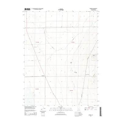
2014 Map of Harding
USGS Topo · Published 2014About this map
The settlement of Harding serves as a focal point in this 2014 survey of the Millard County landscape, situated where the high desert terrain meets engineered irrigation. The path of the Central Utah Canal is a defining element of the local economy, cutting north-to-south through the valley to manage water resources in an arid environment. To the east, the topography shifts abruptly as the ground rises toward Sixmile Point, marked by the natural drainage patterns of Sixmile Wash and Clay Spring Wash. These geographical features dictate the local road network, with routes like Foothill Blvd and Whiskey Creek Rd skirting the base of the upland slopes. The map reflects a landscape organized by both section lines and the necessity of water, where the industrial precision of the canal system contrasts with the irregular contours of the Great Basin foothills.
Find a feature on this map
18 named features on this map. Tap any name to fly to it.
Don’t see what you’re looking for? This feature index may not catch every label — zoom into the map to look around manually.
Map Details
Editions of this 2014 Harding Map
This is the sole edition of this map. No revisions or reprints were ever made.
Other maps of this area

1885 · Sevier Desert
USGS Topo · 1:250,000

1951 · Oak City
USGS Topo · 1:62,500

1953 · Delta
USGS Topo · 1:250,000

1958 · Delta
USGS Topo · 1:250,000

1962 · Delta
USGS Topo · 1:250,000

1962 · Holden
USGS Topo · 1:62,500

1962 · Delta
USGS Topo · 1:62,500

1971 · Pavant Butte North
USGS Topo · 1:24,000
1985 · Harding
USGS Topo · 1:24,000
1985 · Oak City North
USGS Topo · 1:24,000