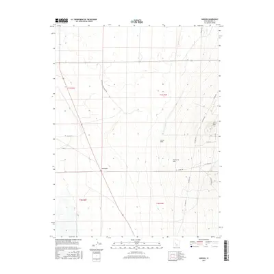
2017 Map of Harding
USGS Topo · Published 2017About this map
Harding stands as a focal point in this Millard County landscape, situated where the high desert terrain meets the engineered water systems of the Sevier Desert. The map illustrates a transitional environment, where the vital flow of the Central Utah Canal supports the surrounding agricultural grid against the arid backdrop of Sixmile Wash and Clay Spring Wash. Local transportation is defined by a network of rural routes including McCormick Rd and Harding Way, which navigate the rectangular townships of the Public Land Survey System.
Find a feature on this map
21 named features on this map. Tap any name to fly to it.
Don’t see what you’re looking for? This feature index may not catch every label — zoom into the map to look around manually.
Map Details
Editions of this 2017 Harding Map
This is the sole edition of this map. No revisions or reprints were ever made.
Other maps of this area

1885 · Sevier Desert
USGS Topo · 1:250,000

1951 · Oak City
USGS Topo · 1:62,500

1953 · Delta
USGS Topo · 1:250,000

1958 · Delta
USGS Topo · 1:250,000

1962 · Delta
USGS Topo · 1:250,000

1962 · Holden
USGS Topo · 1:62,500

1962 · Delta
USGS Topo · 1:62,500

1971 · Pavant Butte North
USGS Topo · 1:24,000
1985 · Harding
USGS Topo · 1:24,000
1985 · Oak City North
USGS Topo · 1:24,000