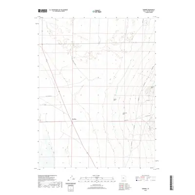
2020 Map of Harding
USGS Topo · Published 2020About this map
The settlement of Harding sits at the intersection of local routes and land management boundaries in this arid stretch of Millard County. The landscape is defined by the vital presence of the Central Utah Canal, which cuts north-south across the high desert terrain to support regional irrigation. This water management infrastructure contrasts with the natural ephemeral drainage patterns of Sixmile Wash and Clay Spring Wash, which flow from the higher elevations of the east toward the valley floor. Toward the northeastern corner of the map, Sixmile Point provides a notable topographic landmark overlooking the network of rural roads such as McCormick Rd and Whiskey Creek Rd. These named routes, including Duckworth Ln and Harding Way, trace the persistent patterns of ranching and land use in this part of the Utah interior.
Find a feature on this map
18 named features on this map. Tap any name to fly to it.
Don’t see what you’re looking for? This feature index may not catch every label — zoom into the map to look around manually.
Map Details
Editions of this 2020 Harding Map
This is the sole edition of this map. No revisions or reprints were ever made.
Other maps of this area

1885 · Sevier Desert
USGS Topo · 1:250,000

1951 · Oak City
USGS Topo · 1:62,500

1953 · Delta
USGS Topo · 1:250,000

1958 · Delta
USGS Topo · 1:250,000

1962 · Delta
USGS Topo · 1:250,000

1962 · Holden
USGS Topo · 1:62,500

1962 · Delta
USGS Topo · 1:62,500

1971 · Pavant Butte North
USGS Topo · 1:24,000
1985 · Harding
USGS Topo · 1:24,000
1985 · Oak City North
USGS Topo · 1:24,000