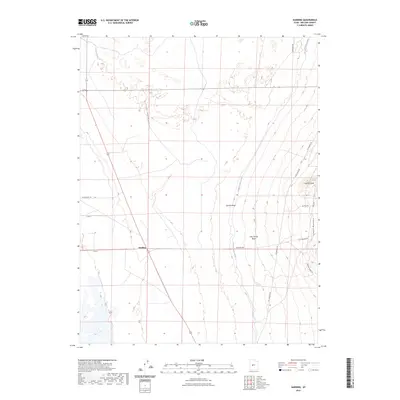
2023 Map of Harding
USGS Topo · Published 2023About this map
The settlement of Harding serves as a focal point in this Millard County landscape, where modern agricultural water management meets the base of the Canyon Mountains. The Central Utah Canal cuts a prominent north-south path through the center of the terrain, illustrating the critical infrastructure required for settlement in this part of the state. This irrigation network is complemented by natural drainage systems like Sixmile Wash and Clay Spring Wash, which flow from the higher elevations of the mountains toward the valley floor.
Find a feature on this map
17 named features on this map. Tap any name to fly to it.
Don’t see what you’re looking for? This feature index may not catch every label — zoom into the map to look around manually.
Map Details
Editions of this 2023 Harding Map
This is the sole edition of this map. No revisions or reprints were ever made.
Other maps of this area

1885 · Sevier Desert
USGS Topo · 1:250,000

1951 · Oak City
USGS Topo · 1:62,500

1953 · Delta
USGS Topo · 1:250,000

1958 · Delta
USGS Topo · 1:250,000

1962 · Delta
USGS Topo · 1:250,000

1962 · Holden
USGS Topo · 1:62,500

1962 · Delta
USGS Topo · 1:62,500

1971 · Pavant Butte North
USGS Topo · 1:24,000
1985 · Harding
USGS Topo · 1:24,000
1985 · Oak City North
USGS Topo · 1:24,000