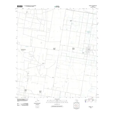
2010 Map of Hargill
USGS Topo · Published 2010About this map
The settlement of Hargill and its surrounding agricultural tracts define this portion of Hidalgo County, captured just as regional infrastructure was expanding in the early twenty-first century. This landscape is characterized by the organized grid of farm-to-market roads and the distinct residential patterns of local colonias, including La Coma Heights Colonia, Harding Gill Tract Colonia, and Hillcrest Terrace Colonia. These developments sit alongside traditional ranching lands like La Coma Ranch, reflecting the area's transition into a more densely populated rural corridor.
Find a feature on this map
28 named features on this map. Tap any name to fly to it.
Don’t see what you’re looking for? This feature index may not catch every label — zoom into the map to look around manually.
Map Details
Editions of this 2010 Hargill Map
This is the sole edition of this map. No revisions or reprints were ever made.
Other maps of this area

1922 · La Sal Vieja
USGS Topo · 1:62,500

1939 · Linn
USGS Topo · 1:62,500

1949 · Mc Allen
USGS Topo · 1:250,000

1953 · Brownsville
USGS Topo · 1:250,000

1954 · McAllen
USGS Topo · 1:250,000

1956 · La Sal Vieja
USGS Topo · 1:24,000

1956 · La Sal Vieja
USGS Topo · 1:62,500

1956 · Brownsville
USGS Topo · 1:250,000

1956 · Port Isabel
USGS Topo · 1:250,000
1957 · Lasara
USGS Topo · 1:24,000
Featured Places
- Edinburg, TX
- Hargill, TX
- Doolittle Acres Colonia, TX
- Edinburg Acres Colonia, TX
- Hillcrest Terrace Colonia, TX