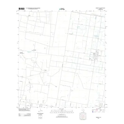
2012 Map of Hargill
USGS Topo · Published 2012About this map
The settlement of Hargill serves as the focal point of this South Texas landscape, where the grid-based agricultural layout of Hidalgo County meets the energy industry. The presence of the San Salvador Gas Field and the Hargill Reservoir highlights the dual reliance on subsurface resources and water management in this arid region. For those tracing family histories, several local burial grounds are documented, including Hargill Cem, Cibilo Cem, and Cavazos Cem. Transportation and aviation are prominent, with the South Texas International Airport at Edinburg and the Omni Ranch Ultralight Flightpark marking the western edge of the quadrangle. Established ranching traditions are represented by La Coma Ranch, while a dense network of rural roads like Brushline RD and FM-490 connect the scattered homesteads and fields.
Find a feature on this map
43 named features on this map. Tap any name to fly to it.
Don’t see what you’re looking for? This feature index may not catch every label — zoom into the map to look around manually.
Map Details
Editions of this 2012 Hargill Map
This is the sole edition of this map. No revisions or reprints were ever made.
Other maps of this area

1922 · La Sal Vieja
USGS Topo · 1:62,500

1939 · Linn
USGS Topo · 1:62,500

1949 · Mc Allen
USGS Topo · 1:250,000

1953 · Brownsville
USGS Topo · 1:250,000

1954 · McAllen
USGS Topo · 1:250,000

1956 · La Sal Vieja
USGS Topo · 1:24,000

1956 · La Sal Vieja
USGS Topo · 1:62,500

1956 · Brownsville
USGS Topo · 1:250,000

1956 · Port Isabel
USGS Topo · 1:250,000
1957 · Lasara
USGS Topo · 1:24,000
Featured Places
- Edinburg, TX
- Hargill, TX
- Doolittle Acres Colonia, TX
- Edinburg Acres Colonia, TX
- Hillcrest Terrace Colonia, TX