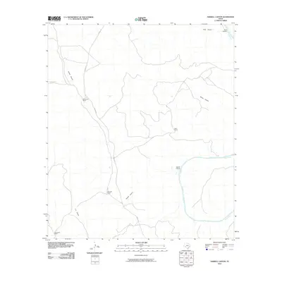
2010 Map of Harkell Canyon
USGS Topo · Published 2010About this map
The Pecos River carves a deep path through this reach of West Texas, defining a landscape of isolated outposts and intricate drainage systems. In this era of modern ranching, family-named holdings like Henderson Ranch, Rose Ranch, and Newman Ranch remain the primary points of human habitation. These settlements are linked by the winding route of Pandale Rd, which traverses the high ground above the canyon floor.
Find a feature on this map
11 named features on this map. Tap any name to fly to it.
Don’t see what you’re looking for? This feature index may not catch every label — zoom into the map to look around manually.
Map Details
Editions of this 2010 Harkell Canyon Map
This is the sole edition of this map. No revisions or reprints were ever made.
Other maps of this area

1943 · Langtry
USGS Topo · 1:62,500

1943 · Shumla
USGS Topo · 1:62,500

1954 · Sonora
USGS Topo · 1:250,000

1958 · Sonora
USGS Topo · 1:250,000

1958 · Del Rio
USGS Topo · 1:250,000

1964 · Del Rio
USGS Topo · 1:250,000

1970 · Everett Canyon
USGS Topo · 1:24,000

1970 · Little Fielder Draw
USGS Topo · 1:24,000

1973 · Langtry
USGS Topo · 1:24,000
1973 · Still Canyon
USGS Topo · 1:24,000