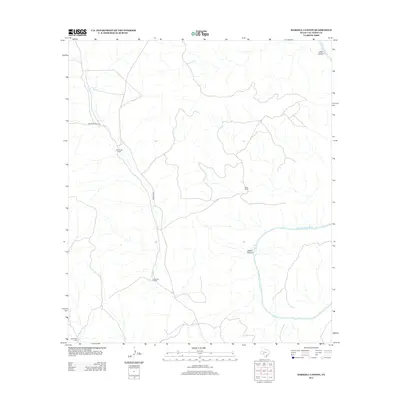
2013 Map of Harkell Canyon
USGS Topo · Published 2013About this map
The Pecos River cuts a deep course through this portion of Val Verde County, defining the drainage patterns and topography of the high desert landscape. The terrain is deeply incised by significant geographic features like Harkell Canyon and Goat Canyon in the northeast. This 2013 survey illustrates a sparsely populated region where human presence is primarily marked by established ranching operations. Significant landholdings including Henderson Ranch, Rose Ranch, and Newman Ranch are connected by a limited network of local thoroughfares. Primary access to these remote outposts is maintained via Pandale Rd and Arledge Ranch Rd, which navigate the plateaus and canyon rims between the Pecos and its northern tributaries.
Find a feature on this map
9 named features on this map. Tap any name to fly to it.
Don’t see what you’re looking for? This feature index may not catch every label — zoom into the map to look around manually.
Map Details
Editions of this 2013 Harkell Canyon Map
This is the sole edition of this map. No revisions or reprints were ever made.
Other maps of this area

1943 · Langtry
USGS Topo · 1:62,500

1943 · Shumla
USGS Topo · 1:62,500

1954 · Sonora
USGS Topo · 1:250,000

1958 · Sonora
USGS Topo · 1:250,000

1958 · Del Rio
USGS Topo · 1:250,000

1964 · Del Rio
USGS Topo · 1:250,000

1970 · Everett Canyon
USGS Topo · 1:24,000

1970 · Little Fielder Draw
USGS Topo · 1:24,000

1973 · Langtry
USGS Topo · 1:24,000
1973 · Still Canyon
USGS Topo · 1:24,000