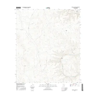
2016 Map of Harkell Canyon
USGS Topo · Published 2016About this map
The Pecos River carves a deep, winding course through this section of Val Verde County, defining the primary drainage for a series of dramatic canyon systems. This 2016 survey highlights the stark relief of the West Texas landscape, where Harkell Canyon and Goat Canyon feed into the river basin from the north and east. The map captures a primarily undeveloped ranching region, anchored by private land access routes like Arledge Ranch Rd and the long north-south corridor of Pandale Rd. Further west, the terrain is marked by G4 Canyon and Moose Canyon, illustrating the complex network of dry draws and steep-walled ravines that characterize this portion of the Edwards Plateau. The cartography provides a clear view of the topographical contours that dictate the movement of water and travelers in this arid environment.
Find a feature on this map
7 named features on this map. Tap any name to fly to it.
Don’t see what you’re looking for? This feature index may not catch every label — zoom into the map to look around manually.
Map Details
Editions of this 2016 Harkell Canyon Map
This is the sole edition of this map. No revisions or reprints were ever made.
Other maps of this area

1943 · Langtry
USGS Topo · 1:62,500

1943 · Shumla
USGS Topo · 1:62,500

1954 · Sonora
USGS Topo · 1:250,000

1958 · Sonora
USGS Topo · 1:250,000

1958 · Del Rio
USGS Topo · 1:250,000

1964 · Del Rio
USGS Topo · 1:250,000

1970 · Everett Canyon
USGS Topo · 1:24,000

1970 · Little Fielder Draw
USGS Topo · 1:24,000

1973 · Langtry
USGS Topo · 1:24,000
1973 · Still Canyon
USGS Topo · 1:24,000